GTA 6 Counties: All 5 Counties on the Official Leonida Map
Hub of GTA Editorial Team
Editorial · Hub of GTA
Confirmed official Rockstar, Take-Two or platform source. Reported a named outlet, not confirmed by Rockstar. Rumour unverified, treat with caution.
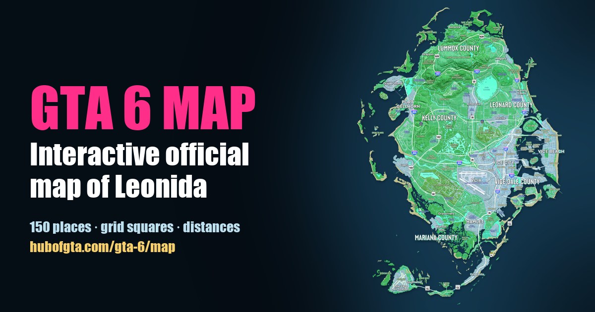
GTA 6's state of Leonida has five counties: Lummox, Kelly, Leonard, Vice-Dale and Mariana. Confirmed All five are named in large type on Rockstar's official Map of Leonida. Vice City sits in Vice-Dale County, Mount Kalaga in Lummox County, and Grassrivers in Mariana County.
The official map prints county names but no county lines. So "what's in each county" below is based on where places are printed relative to the county labels and the map's own sub-area labels, like North Kelly County. Open any of them on our interactive map to see it.
The five counties at a glance
| County | Where | Main places printed there | Real-world parallel |
|---|---|---|---|
| Lummox County | North | Mount Kalaga National Park, Bonanza, Grayson, Moreau | Not confirmed |
| Kelly County | West | Gellhorn, Emerald Springs, Frogswater, Buckskin Swamp | Not confirmed |
| Leonard County | North-east | Lake Leonida, Belville, Millport, Waning Sands | Not confirmed |
| Vice-Dale County | East | Vice City, Vice Beach, VCIA, Tequesta | Miami-Dade County Reported |
| Mariana County | South | Grassrivers, Watson Bay, Pelican Valley | Not confirmed |
Reported Vice-Dale is widely read as Leonida's Miami-Dade, for example by gta-6-map.com. Rockstar hasn't drawn real-world parallels for the counties.
Lummox County (north)
The hill country. Confirmed The official map prints Mount Kalaga National Park directly beneath the Lummox County label, with the towns of Bonanza, Grayson and Moreau around it. You'll also find the MacAlister Gold Mine and Tallaloko Lakeside Resort. The map labels two sub-areas: East Lummox County and South West Lummox County. U.S. Route 628 runs across it.
Kelly County (west)
The biggest stretch of countryside. Confirmed The map's Kelly County label sits between Port Gellhorn on the coast and farmland inland, with North Kelly County and South Kelly County labelled above and below it. Places nearby include Gellhorn, Emerald Springs, Frogswater, Buckskin Swamp, Leonida State Prison and Gellhorn Raceway. Interstate 404 runs down its west side.
Leonard County (north-east)
Built around Lake Leonida, the big round lake in the middle of the state. Confirmed Printed nearby are Belville, Millport, Waning Sands on the coast, and Chateau Cellerica. The map labels North Leonard County and South Leonard County. Interstate 97 runs down its coast towards Vice City.
Vice-Dale County (east)
The urban county. Confirmed Vice-Dale County's label is printed right under Vice City, and the county covers Vice Beach, the islands in the bay such as Starfish Island, Vice City International Airport, Tequesta and Port Vice City. The map also labels West Vice-Dale County and South Vice-Dale.
Mariana County (south)
Wetlands and the south coast. Confirmed Grassrivers is printed just above the Mariana County label, with Watson Bay, Pelican Valley and Henry J Edwards Airport nearby.
Counties vs regions
Rockstar's website describes six regions: Vice City, Leonida Keys, Grassrivers, Mount Kalaga, Port Gellhorn and Ambrosia. These are areas to explore, not county lines, and they overlap the counties:
| Region | County it sits in (by the map) |
|---|---|
| Vice City | Vice-Dale County |
| Mount Kalaga | Lummox County |
| Grassrivers | Mariana County |
| Port Gellhorn | Kelly County |
| Ambrosia | Not clear: it sits between Kelly and Leonard counties |
| Leonida Keys | Not named on the map |
Explore the counties
On the interactive GTA 6 map, open Layers and switch on Counties and County areas to see every county label as a marker. Use the Area tool to outline a county and measure it. For the size of the whole state, see how big the GTA 6 map is.
Frequently Asked Questions
How many counties are in GTA 6?
Five are named on the official Map of Leonida: Lummox County, Kelly County, Leonard County, Vice-Dale County and Mariana County.
What county is Vice City in?
Vice-Dale County. Its name is printed just below Vice City on the official map, and it also covers Vice Beach and the islands in the bay.
What county is Mount Kalaga in?
Lummox County, the northern county. Mount Kalaga National Park is printed directly beneath the Lummox County label.
Are counties the same as GTA 6's regions?
No. Rockstar's six regions (Vice City, Leonida Keys, Grassrivers, Mount Kalaga, Port Gellhorn and Ambrosia) describe areas to explore. The five counties are the state's administrative areas, and they don't line up exactly with the regions.
Does the GTA 6 map show county borders?
No. The official map prints county names but no county lines, so exactly where one county ends and the next begins isn't shown.
Sources
Hub of GTA covers GTA 6 as an independent fan resource. Not affiliated with Rockstar Games or Take-Two Interactive.