GTA 6 Highways: Every Interstate and Route on the Leonida Map
Hub of GTA Editorial Team
Editorial · Hub of GTA
Confirmed official Rockstar, Take-Two or platform source. Reported a named outlet, not confirmed by Rockstar. Rumour unverified, treat with caution.
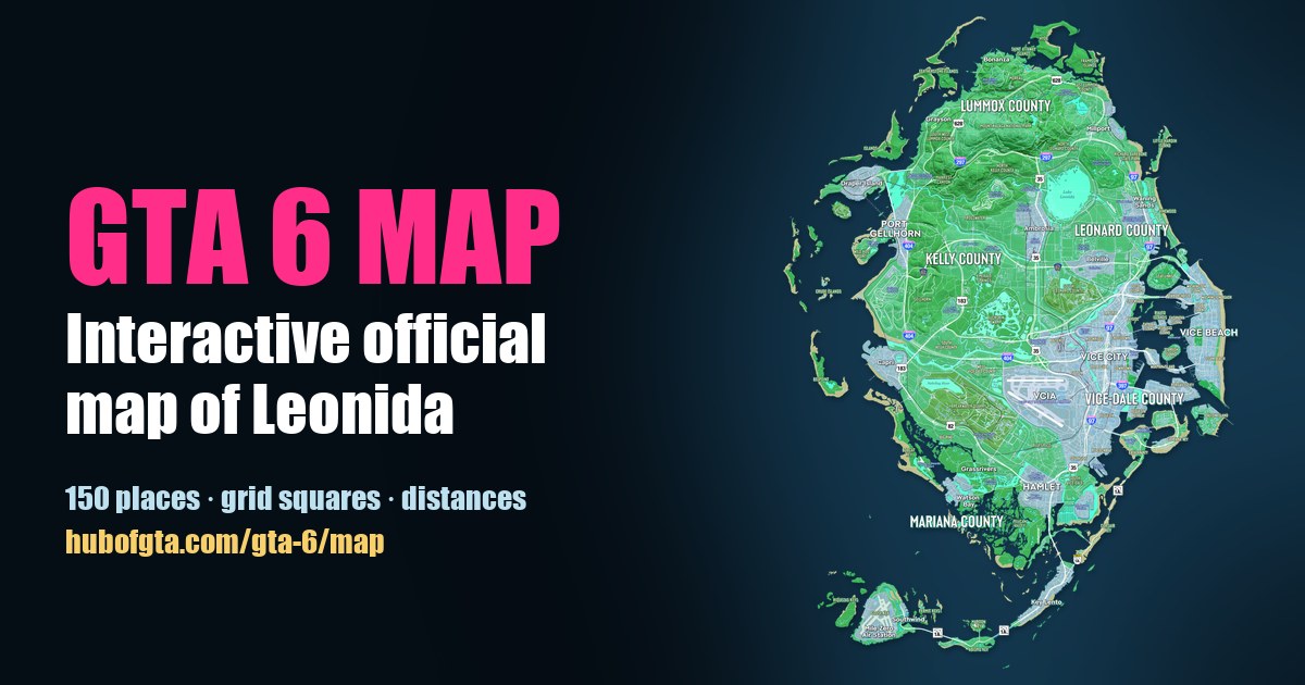
The official GTA 6 map shows 10 numbered roads. Confirmed Rockstar's Map of Leonida prints road signs for four Interstates (97, 297, 397 and 404), four U.S. Routes (35, 82, 183 and 628), State Route 1A and County Route 62. Its legend shows a different sign shape for each kind: Interstate, U.S. Route, State Route, County Route and Toll.
On our interactive GTA 6 map, open Layers and switch on Route shields to see every sign. Click a road below to jump straight to it.
Every numbered road at a glance
| Road | Type | Signs on the map | Runs past (nearest places to its signs) |
|---|---|---|---|
| Interstate 97 | Interstate | 4 | Richard Barebone State Park, Waning Sands, Crosstown (Vice City), Tequesta |
| Interstate 297 | Interstate | 2 | Manifest Canyon, Ambrosia Raceway Park |
| Interstate 397 | Interstate | 1 | Downtown Vice City |
| Interstate 404 | Interstate | 3 | Port Gellhorn, Capri, Tisha-Wocka Flea Market |
| U.S. Route 35 | U.S. Route | 4 | Ambrosia, Allied Crystal, west Vice City, Southside |
| U.S. Route 82 | U.S. Route | 1 | Big Pine |
| U.S. Route 183 | U.S. Route | 2 | Leonida State Prison, Capri |
| U.S. Route 628 | U.S. Route | 2 | Tallaloko Lakeside Resort, Grayson |
| State Route 1A | State Route | 4 | South Vice-Dale, Key Lento, Southwind |
| County Route 62 | County Route | 2 | Gellhorn, Chateau Cellerica |
"Runs past" lists the nearest named place to each sign on the map. It shows roughly where the road goes, not every stop.
Interstates
- Interstate 97 is the east-coast spine. Confirmed Its signs run from Richard Barebone State Park in the north-east, past Waning Sands, through the middle of Vice City at Crosstown, and south to Tequesta. From first sign to last that's about 4.1 miles in a straight line.
- Interstate 404 links the west coast to the city. Confirmed It runs south past Port Gellhorn and Capri, then east towards Vice City.
- Interstate 297 crosses the north. Confirmed It runs through Kelly and Leonard counties between Manifest Canyon and the area north of Ambrosia.
- Interstate 397 is a short downtown spur. Confirmed Its one sign is beside Downtown Vice City.
U.S. Routes
- U.S. Route 35 runs north to south through the middle of the state, past Ambrosia and Allied Crystal, then along the west side of Vice City to Southside. Its signs span about 4.9 miles, the longest of any road on the map.
- U.S. Route 628 loops through the hill country of Lummox County, near Grayson and the Tallaloko Lakeside Resort.
- U.S. Route 183 runs through western Kelly County, from near Leonida State Prison down to Capri.
- U.S. Route 82 runs through the south-west of the state; its one sign on the map is beside Big Pine, near Breakwater Quarry.
State Route 1A: the road to the Keys
Confirmed State Route 1A runs south from South Vice-Dale, past Key Lento, and along the island chain to Southwind and Mile Zero Air Station. One of its signs carries the map's Toll marker. It plays the part of Florida's Overseas Highway: see GTA 6 map vs real Florida.
County Route 62
Confirmed The only county road on the map runs east-west across the middle of the state, from Gellhorn in Kelly County towards Chateau Cellerica and Belville in Leonard County.
Plan a route
Use the Distance tool on the interactive map to click along any road and get its length in miles or km, using the scale printed on Rockstar's map. For distances between towns, see how big the GTA 6 map is.
Frequently Asked Questions
What highways are in GTA 6?
The official map shows Interstates 97, 297, 397 and 404, U.S. Routes 35, 82, 183 and 628, State Route 1A and County Route 62.
Which GTA 6 highway goes to the Keys?
State Route 1A. It runs south from near Hamlet past Key Lento and along the Leonida Keys to Southwind and Mile Zero Air Station.
Which highway connects Vice City to the north?
Interstate 97 runs up the east coast from Tequesta through Vice City towards Waning Sands and Richard Barebone State Park. U.S. Route 35 runs north-south through the middle of the state, past Ambrosia.
How does Port Gellhorn connect to Vice City?
Interstate 404 runs down the west side past Port Gellhorn and Capri, then turns east towards Vice City.
Sources
Hub of GTA covers GTA 6 as an independent fan resource. Not affiliated with Rockstar Games or Take-Two Interactive.