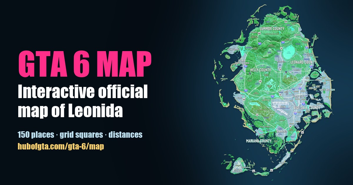
GTA 6 Landmarks: All 33 Places Marked on the Official Map, Region by Region
Hub of GTA Editorial Team
Editorial · Hub of GTA
Confirmed official Rockstar, Take-Two or platform source. Reported a named outlet, not confirmed by Rockstar. Rumour unverified, treat with caution.
Rockstar's official Map of Leonida marks 33 landmarks. Confirmed They include 4 race venues, 4 airports and airfields, 5 parks and wild areas, 2 prisons, plus arenas, malls, farms and industry, all printed by name on the free official map. Below is every one, north to south, with the nearest town and the nearest numbered road sign. Click any name to open it on our interactive GTA 6 map.
Distances are straight lines between the printed labels, using the map's own scale. Want them by type instead? See the map directory: racetracks, airports, parks, venues, farms and industry and prisons.
The north: Mount Kalaga and Lummox County (6)
| Landmark | Grid | Nearest town | Nearest road sign |
|---|---|---|---|
| Mount Kalaga National Park | C5 | Moreau, 0.8 mi | US-628 |
| MacAlister Gold Mine | C5 | Bonanza, 0.4 mi | US-628 |
| Tallaloko Lakeside Resort | C6 | Millport, 0.8 mi | US-628 |
| Richard Barebone State Park | D7 | Millport, 0.7 mi | I-97 |
| Mount Hailes Country Club | D7 | Millport, 0.6 mi | I-97 |
| Father Scrumpy's Red Apple Orchard | D4 | Port Gellhorn, 1.0 mi | I-297 |
Confirmed Mount Kalaga National Park is the hill country printed beneath the Lummox County label, and the gold mine and lakeside resort sit beside it along U.S. Route 628. More in GTA 6 counties explained.
The middle: Lake Leonida and Ambrosia (9)
| Landmark | Grid | Nearest town | Nearest road sign |
|---|---|---|---|
| Evergreen Mall of Waning Sands | E7 | Sabal Palms, 0.3 mi | I-97 |
| Chateau Cellerica | E6 | Belville, 0.3 mi | CR-62 |
| Allied Crystal | E5 | Ambrosia, 0.2 mi | US-35 |
| Ambrosia Raceway Park | D5 | Ambrosia, 0.7 mi | US-35 |
| Ambrosia Rodeo Association | E5 | Ambrosia, 0.4 mi | US-35 |
| Tucker's Citrus Farms | E5 | Emerald Springs, 0.5 mi | US-35 |
| Howe Dairy | E4 | Frogswater, 0.4 mi | CR-62 |
| Thrillbilly Mud Club | E5 | Frogswater, 0.5 mi | US-35 |
| Manifest Canyon | D4 | Frogswater, 0.8 mi | I-297 |
Confirmed Allied Crystal, the sugar refinery Rockstar has shown, is printed just south of Ambrosia by Lake Leonida. Reported Ambrosia is widely compared to Clewiston, Florida's sugar town on Lake Okeechobee; see GTA 6 map vs real Florida.
The west coast: Port Gellhorn and Kelly County (4)
| Landmark | Grid | Nearest town | Nearest road sign |
|---|---|---|---|
| Wild Hog Airfield | E3 | Port Gellhorn, 0.4 mi | I-404 |
| Gellhorn Raceway | F3 | Gellhorn, 0.5 mi | CR-62 |
| Leonida State Prison | F4 | Gellhorn, 0.5 mi | US-183 |
| Buckskin Swamp | G5 | Emerald Springs, 0.7 mi | US-183 |
Vice City (6)
| Landmark | Grid | Nearest neighbourhood | Nearest road sign |
|---|---|---|---|
| Fleeca Field | G6 | Rockridge, 0.2 mi | I-97 |
| Sahara Arena | G7 | Flam, 0.2 mi | I-397 |
| Tisha-Wocka Flea Market | G6 | Balsero, 0.3 mi | US-35 |
| Vice City International Airport (VCIA) | H6 | Salton, 0.7 mi | US-35 |
| Vice City Oceanarium | I7 | Tequesta Retreat, 0.3 mi | I-397 |
| Courtland Park | I7 | Tequesta Retreat, 0.5 mi | I-97 |
The city's 17 neighbourhoods are in GTA 6 Vice City neighbourhoods.
The south: Grassrivers, Hamlet and the Keys (8)
| Landmark | Grid | Nearest town | Nearest road sign |
|---|---|---|---|
| Breakwater Quarry | H4 | Big Pine, 0.6 mi | US-82 |
| Sahara Network Data Center | I5 | Grassrivers, 0.6 mi | US-82 |
| Paradise RV Park | I5 | Grassrivers, 0.3 mi | US-82 |
| Henry J Edwards Airport | I4 | Big Pine, 0.5 mi | US-82 |
| Hamlet Correctional Institution | I5 | Hamlet, 0.2 mi | US-35 |
| Boone Speedway | J5 | Hamlet, 0.2 mi | US-35 |
| T.H. Power Station | J6 | Peacock Estates, 0.7 mi | SR-1A |
| Mile Zero Air Station | L3 | Southwind, 0.5 mi | SR-1A |
Confirmed Mile Zero Air Station is the last landmark at the south-western end of State Route 1A, about 6 miles from Vice City in a straight line. See every GTA 6 highway for how the roads connect.
What the map doesn't show
The official map marks landmarks, towns and roads, but not gameplay spots like stores, ATMs, safehouses or collectibles. We're mapping those in the map directory, one sourced pin at a time, and you can suggest a pin with a video or screenshot.
Frequently Asked Questions
What landmarks are on the GTA 6 map?
The official Map of Leonida marks 33, including Mount Kalaga National Park, Lake Leonida's Allied Crystal sugar refinery, Ambrosia Raceway Park, Gellhorn Raceway, Leonida State Prison, Sahara Arena, the Vice City Oceanarium, Vice City International Airport and Mile Zero Air Station.
How many airports are in GTA 6?
The official map marks four: Vice City International Airport (VCIA), Henry J Edwards Airport, Wild Hog Airfield and Mile Zero Air Station.
How many racetracks are in GTA 6?
Four race venues are printed on the official map: Gellhorn Raceway, Ambrosia Raceway Park, Boone Speedway and the Thrillbilly Mud Club.
Are there prisons in GTA 6?
The official map marks two: Leonida State Prison in Kelly County and the Hamlet Correctional Institution near Hamlet.
Sources
Hub of GTA covers GTA 6 as an independent fan resource. Not affiliated with Rockstar Games or Take-Two Interactive.